General Changes for the 2nd Edition: |
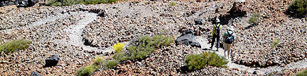
- The legend for the map’s line styles was inadvertently
left out. The solid lines are for standard routes, which are always route
1 in the text. Variations have a unique, dedicated, non-solid line style throughout
the book. Extra Credits have a unique, dedicated, non-solid line style throughout
the book. Alternate routes have a different, non-solid line style for each
peak in a group.
- The USGS has changed datums, and announced new altitudes for all of Colorado’s Fourteeners.
The USGS adjusted the elevations for all Fourteeners upwards from three to seven feet.
The peaks have not instantly gained height, since this is just a mathematical adjustment.
For a list of the old and new elevations, see Gerry’s
Fourteener List.
- In the first printing of the Second Edition, there were some errors
on the overview map on page xxvi. This was corrected in later printings.
- The Leave No Trace Organization has rearranged some of their verbiage,
and added new guidelines, which are respect wildlife and be considerate of others
that you meet on the trail. See www.lnt.org
for more information.
- After reviewing the list of peaks, Gerry made the following revisions to the Prom column:
- La Plata: 2,276 -> 1,836
- Longs: 2,940 -> 2,955
- Princeton: 2,431 -> 2,177
- Sneffels: 3,930 -> 3,050
- Eolus: 3,863 -> 2,183
- Handies: 2,148 -> 1,908
- Culebra: 4,667 -> 4,827
- San Luis: 3,116 -> 3,114
|
Peak Specific Changes in Book Order for the 2nd Edition: |
1. Longs Peak |
- The second paragraph in the description of Route 1.1EC3 on page 8 should begin,
“If you are in the Boulder Field, hike east for 0.3 mile, then south up blocky talus
for 0.15 mile to the summit, ...”
|
2. Grays Group |
- The approach to the Stevens Gulch Trailhead described on page 17 is no longer “passable for
most passenger cars.” This road (FR 189) has become rougher in recent years, and it has been
re-classified as “High Clearance Vehicles Only.” There is a sign at the bottom of the
hill advising motorists of this fact. Heed it.
|
3. Evans Group |
- The Guanella Pass Road has been upgraded and paved over the summit of the pass.
There are now two new parking lots near the summit of the pass, one on the east side of the road
just north of the pass and one on the west side of the road just west of the pass.
The Guanella Pass Trailhead on Page 31 has moved from the old parking lot right on the pass to
the new parking lot on the east side of the road. This change reduces the round-trip elevation gain
from this trailhead by 60 feet. Arrive early at this trailhead, for once the parking lots are full,
you may not be allowed to hike toward Bierstadt.
- The line for Route 3.13, Bierstadt’s West Slopes Route, on Map 3 on page 32 is slightly off.
The printed line directly up the slope is the old, disused trail. The new, improved CFI trail is a
little to the north of the printed line, and the new trail reaches the crest of Bierstadt’s
northwest ridge.
|
4. Pikes Peak |
- Under Pikes Peak on Page 48, the contact number for Barr Camp Reservations (719) 630-3934
is no longer valid. The current contact is
www.barrcamp.com.
- The trail system east of the Crags Campground Trailhead on page 45 has been improved.
There is now a signed trail junction and a bridge across the creek to reach
the southern drainage that leads to Devil’s Playground.
|
5. Quandary Peak |
- The Monte Cristo Trailhead described on page 55 is no longer in use since the trailhead
and first part of Quandary’s East Slopes Route above it is on private property.
To accommodate hikers on this popular Fourteener, the Forest Service has constructed a
new trailhead nearby, and rerouted the first part of the East Slopes Route.
I call the new trailhead the Lower McCullough Gulch Trailhead.
To reach it from Colorado 9, go west on Summit County 850 for 0.1 mile, turn north (right)
onto Summit County 851 and go 1.0 mile to the new trailhead.
A trail goes southwest from the new trailhead to join the original route at the base of
Quandary’s lower east slopes.
|
6. Lincoln Group |
- Access to Lincoln, Democrat and Bross is currently restricted. Old mining claims, long strips
of private land, crisscross the slopes of these peaks, and the current owners fear that hikers
might fall into old mine shafts. The state legislature passed a new statute that limits land
owner’s liability in cases like this, but the routes remained restricted in 2008. Access to
these peaks is being worked on, and hopefully there will be a coherent solution for the 2009 season.
See
http://www.fs.fed.us/r2/psicc/news/2006/nr_sopa_040306.fourteeneraccess.shtml
for contacts and more information.
|
7. Mount Sherman |
- Route 7.4 on Mount Sherman that originates at the Sacramento Creek Trailhead,
which is described on page 73 and goes southwest above Sacramento Creek, is no longer accessible.
It is blocked by private property that is guarded by a sanctimonious landowner.
The USFS has not been able to help the public gain access to Sacramento Creek.
Do not use the Sacramento Creek Trailhead.
- The Little Sacramento Trailhead, described on page 71, is on private property.
Do not use the Little Sacramento Trailhead to gain access to Route 7.3 on Mount Sherman.
At this point, there is no public access to Mount Sherman’s Route 7.3.
- The Mount Sherman Map on page 72 has an error. The 4WD parking above the Fourmile Creek Trailhead
is at 12,520 feet, not 11,680 feet as printed.
|
8. Mount of the Holy Cross |
- The White River National Forest Ranger Station has moved from the referenced location
at Main and Harrison in the center of Minturn to a spacious location just south of Exit 171
on Interstate 70. Accordingly, the directions to the Halfmoon Trailhead on
page 78 should read, “A few miles west of Vail, take Exit 171 off Interstate
70. From the U.S. 24-Interstate 70 junction, go 2.0 miles south on U.S. 24
to Main and Harrison Streets in the town of Minturn, continue 2.8 miles south on
U.S. 24 and turn west (right) onto Tigiwon Road (FS 707).”
- Map 8’s dashed line for Routes 8.2, 8.3 and 8.4 on Mount of the Holy Cross on Page 77
is slightly incorrect near Lake Patricia. Instead of going along Lake Patricia’s
west shore as shown, the trail stays 200 yards west of the lake.
- The Eagle County Sheriff’s office and local search and rescue teams have responded
to many rescue calls in recent years on the Mount of the Holy Cross. They have asked me to
better educate hikers about the special hazards found on this peak, and I am happy to do that.
Holy Cross has three hazards that are unique to this peak.
First, is the fact that when climbing the standard North Ridge Route, you must go over
Half Moon Pass, then descend 970 vertical feet to East Cross Creek, then climb the mountain.
The hidden hazard is that you must reclimb the 970 feet to Half Moon Pass on your return trip.
This extra climb pushes the total ascent on the North Ridge Route to over 5,600 feet. This is
more gain than the standard Keyhole Route on Longs Peak, which many people consider to be a
very arduous climb.
The second unique hazard on Holy Cross is at the point where the standard North Face Route
reaches the lower north ridge near 11,500 feet. On descent, many hikers reach this point,
and continue straight down the now broad ridge instead of turning east (right) for the descent
back into the East Cross Creek drainage. This is a bad error, since it is a significant
departure from the route, and the error does not fail safe. If you persist in this erroneous
descent, you will encounter increasingly steep and rough terrain. Eventually, you will reach
the Cross Creek valley, which does have a trail in it, but this trail will not lead you back
to the Halfmoon Trailhead.
The third and most poignant hazard is not on the standard North Ridge Route, but on the much
longer and more exposed Halo Ridge Route. One party of two found the length of
this route to be too much for their conditioning, and made the choice to separate in the
saddle between 13,831-foot Holy Cross Ridge and Holy Cross. The man went to the summit of
Holy Cross while the woman agreed to contour below the summit of Holy Cross near the
13,800-foot level, and meet the man on the upper part of the North Ridge Route,
which was their intended descent route. In spite of an enormous, lengthy search,
the woman was never seen again. My personal opinion
about what happened is that the woman started the contour and found it to be much
longer and rougher than expected. In fact, this contour may be more difficult than going
over the summit. In general, it is very difficult to hold a strict contour, especially if
you are tired. My theory is that the woman lost altitude during her attempt to contour,
then ran into a gully, that could easily have drawn her even lower in an attempt to cross
the gully. At this point she was in the middle of the large west face of Holy Cross,
and badly off route. By choice or chance, she must have descended into the trees,
where the terrain steepens. There are small cliffs hidden in these trees, and any
stumble or fall, could have quickly left her in a life-threatening situation.
Now, years later, she has still never been found. This sad story should
be sufficient motivation for you to approach this mountain properly conditioned and
equipped.
|
9. Mount Massive |
- Mount Massive’s East Slopes Route 9.1 has been rerouted slightly.
The trail has been moved to the south to avoid a sensitive wetland area near 13,200 feet.
- Mount Massive’s Southwest Slopes Route 9.3 has been rerouted significantly.
The trail has been moved to the north to avoid an erosion gully near 13,200 feet.
|
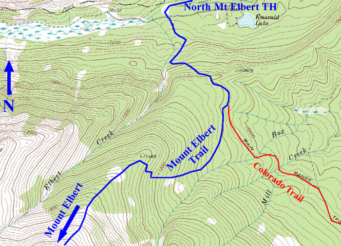
10. Mount Elbert |
- The North Mount Elbert Trailhead on page 93 is 0.4 mile east of the Mount Massive Trailhead at mile 6.6,
not mile 6.9 as stated. The North Mount Elbert Trailhead is 0.1 mile east of the Elbert Creek Campground.
- The junction of the Colorado Trail and Mount Elbert Trail as shown on Map 10 on page 92 is slightly off.
The trail junction is 0.2 mile south of the point where the Colorado Trail reaches the crest of the slope
above Halfmoon Creek. Here is a more accurate rendition of the trail:
- There is an error in the description of Route 10.3 - Elbert’s Southeast Ridge. The last sentence on page 96
should begin, “Descend northwest to the broad, 13,900-foot saddle ...”
|
11. La Plata Peak |
- The dashed line for La Plata’s Route 11.3 on Map 11 on
page 100 is wrong in three places. First, the 2WD West Winfield Trailhead
should be at Winfield instead of 0.6 mile up the now-rougher road. Second,
the marked position for the 4WD parking is slightly off. The correct position
is at 10,900 feet just east of the creek 0.2 mile east of the creek coming
from the basin between Sayers Benchmark and La Plata. Third, the trail in
the basin does not climb to 13,000 feet in the basin before climbing west
to the ridge at 13,200 feet. In reality, it climbs to 12,100 feet in the basin,
then climbs west-northwest to the Sayers Benchmark-La Plata saddle at 12,780
feet. From there, the route climbs northeast on the west side of the ridge.
- In the description on page 101 for La Plata’s Route 11.1 the Northwest Ridge,
the “log bridge” a half a mile from the Lake Creek Trailhead has been replaced
by a steel bridge. More importantly, the text “After crossing the bridge, go north
(left)” should read “After crossing the bridge, go south (right).”
If you turn left, you will reach private property. Do not trespass.
|
12. Huron Peak |
- Route 12.1, the standard route on Huron, is now a Colorado Fourteener Initiative Trail,
which is Class 1 all the way to the summit.
- The location of the 4WD parking spot above the Rockdale Trailhead is
mis-marked on Map 12 on page 104. The correct position is in a meadow
at 10,895 feet, which is 0.25 mile south of the marked position.
|
13. Belford Group |
- The location of the 4WD parking spot above the Rockdale Trailhead is
mis-marked on Map 13 on page 108. The correct position is in a meadow
at 10,895 feet, which is 0.25 mile south of the marked position.
- The position of the Clohesy Lake 4WD Parking on Map 13 on page 108 is slightly off.
|
17. Mount Antero |
- The description for Route 17.3 - Little Browns Creek should read,
“From Browns Creek TH at 8,920 ft: 14.0 mi RT 5,349 ft total Class 2
This long route provides an escape from the 4WD road. Start at the Browns Creek Trailhead at 8,920 feet
and follow the Browns Lake Trail 1.3 miles west to the Colorado Trail. At this point Little Browns Creek
is just 150 yards to the south. In a counter-intuitive move, turn north (right) and follow the Colorado Trail
0.5 mile north to the signed Little Browns Creek Trail, which is just south of the point where the Colorado Trail
crosses a small creek. The Little Browns Creek Trail starts as an old rocky road that climbs southwest up a hill.
Do not confuse Little Browns Creek with Browns Creek to the south, since the two creeks drain different valleys.
Little Browns Creek is in the higher, narrower valley between Mount White and Antero. Leave the Colorado Trail
and hike southwest then west on the Little Browns Creek Trail, which is a good trail that many maps do not show.
The climb up this enchanting valley is steep, steady and long. From just beyond treeline at 12,000 feet,
leave the Little Browns Creek Trail and climb 1.0 mile northwest to Anteros summit (Class 2).”
|
18. Shavano Group |
- The USFS is discouraging use of the Jennings Creek Trailhead on page 137.
They prefer that people climb Tabeguache by climbing Shavano from the east, traversing to
Tabeguache, then returning the same way. This is an unreasonable itinerary for a
standard route to Tabeguache that exposes people to a much greater lightning hazard.
|
19. Crestone Group |
- The summit of Kit Carson Mountain was on private property, but it became National Forest land
when the Great Sand Dunes National Park land acquisition was finished.
- On Kit Carson’s East Ridge Route 19.17 on page 164, the referenced
gully used to reach the connecting ridge between Humboldt and the Bears’s
Playground is 0.7 mile farther to the west than shown on Map 19 on page
148. You can traverse the ridge as shown, but it is rough in spots.
- There is a typo with the mileage and elevation gain for Humboldt’s
West Ridge Route 19.14 on page 162. The route statistics should read,
“From South Colony Trailhead: 16.0 miles, 5,320 feet.”
- Hiking access above the Cottonwood Creek Trailhead described on page 146 is now restricted.
- As of summer, 2009, the USFS has closed the South Colony Lakes Road at the Rainbow Trail about halfway up the road.
They have constructed a new trailhead at the new road closure. This closure adds 5 miles roundtrip to all routes
from the South Colony Trailhead.
|
21. Culebra Peak |
- The western approach to Culebra Peak is now owned by the Cielo Vista Ranch. They do accept some reservations
each year for climbs of Culebra and neighboring peaks. They have been charging a fee of $100 per day per person
for climbs of Culebra. Contact the ranch at cielovistaranch@hillranch.com or 254-897-7872 or 254-897-9537
for more information.
|
24. Maroon Bells Group |
- On Route 24.1, the standard route up Maroon Peak, the point where the route leaves the Maroon Creek Trail
and starts steeply up the hill is now graced with an evident use trail. This point is 100 yards north of the
creek crossing at 10,500 feet. There is a nice campsite between the use trail and the creek crossing.
There is no sign indicating the beginning of the use trail, just a cairn.
- On Route 24.4, the standard route up North Maroon Peak, the important use trail that takes you from the
Buckskin Pass Trail into the basin below the northeast ridge leaves the Buckskin Pass Trail 0.6 mile above
the trail junction near Crater Lake in a meadow at 10,800 feet. This is a little farther and higher than the
printed 0.5 mile and 10,700 feet. There is no sign indicating the beginning of the use trail, just a caring.
- On Route 24.7, the standard route up Pyramid Peak, the Fourteener Initiative has constructed a good approach
trail leading from the Maroon Creek Trail into Pyramid’s north basin. As printed, the approach trail begins
in a rocky area 1.1 miles above Maroon Lake at 10,120 feet. There is no sign indicating the beginning of the use
trail, just a caring. There is a second start for the approach trail a few hundred yards farther west, which you
would use if you were camped near Crater Lake. There is no sign indicating the beginning of the
approach trail, just a caring.
|
27. Uncompahgre Group |
- The Fourteener Initiative has constructed a new trail that climbs through the basin southeast of Wetterhorn.
The new trail is 200 yards south of the position marked on Map 27 on page 223.
Also, there is a well-defined use trail that climbs over the top of Point 13,117.
- There is a typo on page 229. The sentence in the second paragraph that reads in part,
“... enter the Big Blue Wilderness at 10,580 feet.” should read,
“... enter the Big Blue Wilderness at 11,580 feet.”
|
28. Handies Group |
- Route 28.10 on Handies west slopes, described on page 240, is now a good trail all the way to the summit.
The route line for this route on Map 28 on page 234 is a little off. The new trail is south of the printed line,
and even though this route is slightly longer, it is best to stay on the trail to avoid damaging the loose slopes.
Also, Variation 28.10V is best avoided for the same reason.
|
29. Eolus Group |
- The Durango-Silverton Railroad now charges $62 roundtrip no matter where you get on or off. No exceptions.
You can still hand the conductor $31 cash for a one-way ride out from Needleton in either direction.
- Gerry has a new DVD to the 3 Fourteeners in this group, Sunlight, Windom, and Eolus. See
Chicago Basin and its Fabulous Fourteeners
for details.
|
31. Wilson Group |
- Approach 31.A1 - the Silver Pick Basin Approach on page 264 has changed.
After a period of closure, there is now a new Forest Service trailhead 1.3 miles above
the old Silver Pick Trailhead referenced on page 261. The Silver Pick Basin Approach
referenced on page 264 is similar, but has changed slightly to avoid the remaining private property in the basin.
The new approach route is well signed.
- In the description for the Navajo Lake and Kilpacker Basin Trailheads on page 263, the distance
from the Rico Post Office to the turn onto the Dunton Road is 6.5 miles, not 9.5 miles.
- In the description for the Navajo Lake Trailhead on page 263,
the sentence in the middle of the second paragraph should read,
“...descend west toward the West Dolores River, turn hard north (right) at mile 7.2
(37.8029° -108.0639°), go north on a spur road and reach the trailhead at mile 7.3.”
- The West Ridge of El Diente, Route 31.7, is very loose, and some people have found it to be
much harder than their expectations.
|
| Return to the Fourteener Book’s Main Menu. |