|
|
|
|
|
|
|
|
|
|
|
|
|
|
|
|
|
|
 |
 |
|
|
 |
|
|
I don’t confuse well. – Tim Meehan |
|
Parkview Mountain – 12,296 feet |
|
This touted Twelver is on the Continental Divide 2.8 miles southwest of Willow Creek Pass. Parkview is the highest peak in the Rabbit Ears Range, and one of the most prominent peaks in Colorado. From Parkview’s summit you can see most of Colorado’s north central mountains. |
|
 |
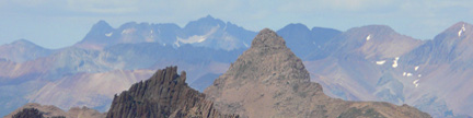
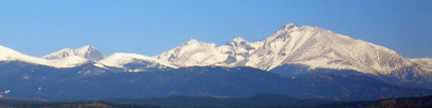
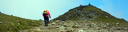
Parkview Mountain from the east You can see the east side hiking routes on either side of the cirque below the summit The Southeast Ridge Route is left of the summit, and the Northeast Ridge Variation is right of the summit Gerry took this photo on 2/15/04 from the summit of Seven Utes Mountain |
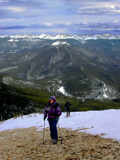 |
Jennifer Roach and Jim Long ascending Parkview’s northeast ridge on a late winter day The Never Summer Range forms the skyline to the east, and Radial Mountain is below the skyline with it’s intermittent radial dike leading down toward Colorado 125 Willow Creek Pass is above Jennifer’s head Gerry took this photo on 3/14/04 |
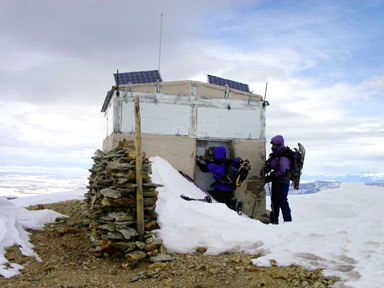 |
Susan Cooper and Jennifer Roach enduring a blasting, pre-storm wind at the lookout shelter on top of Parkview Mountain Gerry took this photo on 3/14/04 |
USGS 7.5’ Quadrangles: Parkview Mountain, Radial Mountain |
|
| This route is best done in summer. For a winter route, try the Northeast Ridge. | Start at the Willow Creek Pass Trailhead on Colorado 125 at 9,600 feet. Cross to the west side of the highway, find the trail sign for the Continental Divide Trail and follow the trail west for 200 yards to it’s intersection with an old road (FR 266-1H). Go 0.5 mile west-northwest on this road to an intersection by the ruins of an old cabin at 9,940 feet. Turn southwest (left) here, and go another 1.0 mile southwest on the road to a road junction at 10,340 feet, which is below a broad avalanche chute. Turn south (left) here and continue another 1.4 miles southwest on the road as it winds up into the basin below Parkview’s summit. En route, you can see the small building on the summit. When the road ends in the basin, climb steeply 0.3 mile south on a cairned route to reach the southeast ridge at 11,400 feet. Turn southwest (right) and climb 0.4 mile up this ridge to reach Parkview’s summit ridge at 12,200 feet. Turn northwest (right), and enjoy your 0.3 mile stroll along this gentle ridge to the highpoint. |
| The Forest Service maintains a small, but sturdy lookout building on the summit. If it is not locked, it can provide a nice shelter from the wind. The view from Parkview’s summit is expansive in all directions, and you can see the following ranges: Rabbit Ears, Park, Medicine Bow, Rawah, Never Summer, Rocky Mountain National Park, Indian Peaks, James Peak Wilderness, Collegiate, Tenmile-Mosquito, Gore, and the Flat Tops. If that isn’t enough, then you will need a trip on the space shuttle. | |
Variation – Northeast Ridge |
|
| This is a better winter route than the upper Southeast Ridge Route, since it avoids the avalanche-prone basin below the summit. Follow the Southeast Ridge Route for 1.6 miles to the road junction at 10,340 feet, which is below a broad avalanche chute. | |
| Leave the Southeast Ridge Route here, turn hard north (right), and go 200 yards north on the road to reach the northeast ridge at 10,460 feet. Leave the road here, and follow the ridge 0.4 mile southwest to treeline at 11,000 feet. Continue 200 yards up the steep slope above, which can hold hard snow in winter. In summer there is a small use trail here to help you negotiate the loose scree. At 11,400 feet, the slope angle relents, and you can continue more easily for 0.3 mile to tiny Point 11,715, from which you can see the rest of the route and the lookout shelter on the summit. The rest of the hike is elemental. Hike 0.4 mile southwest to Point 12,300, turn south (left) and hike 0.4 mile along the gentle summit ridge to the highpoint. | |
Copyright © 2001-2023 by Gerry Roach. All Rights Reserved. |