With the best equipment in the world,
the man with poor judgment is in mortal danger.
– Royal Robbins |
Trailheads for Colorado’s Classic Peaks
We present the trailhead descriptions alphabetically by name within each range. |
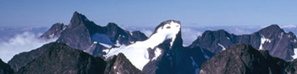
Front Range |
- USGS 7.5´ Quadrangle: McHenrys Peak
- Latitude and Longitude: 40° 18.64´ N; 105° 38.41´ W
- Altitude: 9,180 feet
|
| This trailhead provides access to the North Longs Peak Trail, the Glacier Gorge Trail,
and the Loch Vale Trail, which provide access to many classic Rocky Mountain National Park peaks.
For many decades, this trailhead was located at a switchback in the road at 9,240 feet. With the
advent of increased visitation, the park service relocated the trailhead a quarter mile lower on
Bear Lake Road. The new trailhead has more parking spaces, a shuttle bus stop, and toilets. |
| From Rocky Mountain National Park Headquarters on U.S. 36, go 1.2 miles west to the Beaver
Meadows Entrance Station. Continue west on U.S. 36 for another 0.2 mile, turn south (left)
onto Bear Lake Road, and follow it 8.4 miles to the trailhead. |
| On a busy summer day, the parking lot at the Glacier Gorge Trailhead can be full by 8 a.m.
One alternative is to take the shuttle bus that serves this trailhead and the
Bear Lake Trailhead a mile farther up the road. The park and ride for the shuttle bus is
4.8 miles up the Bear Lake Road. The free bus service runs daily from June 16th to October 1st
from 7 a.m. to 7 p.m., and the last bus leaves the Bear Lake Trailhead at 7:30 p.m. There is
also a shuttle bus from Estes Park to the park and ride on the Bear Lake Road. Another
alternative is to park at the Bear Lake Trailhead and walk 0.5 mile on a trail to join
the trail above the Glacier Gorge Trailhead. This walk is only 0.2 mile longer than the
walk from the Glacier Gorge Trailhead. |
- USGS 7.5´ Quadrangle: Clark Peak
- 2WD Latitude and Longitude: 40° 34.97´ N; 105° 58.18´ W
- 4WD Latitude and Longitude: 40° 35.42´ N; 105° 56.78´ W
- Altitude: 9,560 feet
|
| This trailhead provides access to the west sides of
the high peaks in the central Rawahs including Clark Peak. From the small
town of Gould on Colorado 14 west of Cameron Pass, go 2.0 miles north on Colorado
14, turn west (right) onto Jackson County 41 at a KOA Campground and measure
from this point. Go west on Jackson County 41, enter the Colorado State Forest
(fee required) and reach the Upper Michigan Reservoir Dam at mile 2.1. Go
around the reservoir’s north side, and go straight at mile 3.5 at a junction
where the road to the Bockman Lumber Camp Road goes to the southeast (right).
Do not go to the Bockman Lumber Camp, but continue on Jackson County 41 as
it turns to the north, turn west (right) at mile 5.1 onto a smaller dirt road
that is signed for, “Jewel Lake” and reach a parking lot on the road’s
north (left) side at mile 6.1. This is the trailhead for 2WD vehicles at 9,560 feet.
4WD vehicles can continue west up the steep, rough road to a parking area
at the end of the road at mile 8.6. This is the trailhead for 4WD vehicles
at 10,370 feet. |
- USGS 7.5´ Quadrangle: Estes Park
- Latitude and Longitude: 40° 24.11´ N; 105° 31.30´ W
- Altitude: 7,940 feet
|
| This trailhead provides access to the Gem Lake and Black Canyon Trails,
and all of Lumpy Ridge above Estes Park. From the intersection of U.S. 36 and U.S. 34
on the east side of Estes Park, go 0.5 mile north then west on U.S. 34,
and turn north onto Larimer County 43, which is signed for Glen Haven.
Go 0.7 mile north on Larimer County 43 to a sharp east (right) turn,
and continue straight onto a dirt road. Go 0.9 miles north on this road to the
signed trailhead, which is just inside Rocky Mountain National Park. |
Gore Range |
- USGS 7.5´ Quadrangle: Vail East
- Latitude and Longitude: 39° 39.02´ N; 106° 19.26´ W
- Altitude: 8,420 feet
|
| This trailhead provides access to the Booth Creek Trail (FT #1885), which goes north to Booth Lake,
and provides access to many Gore Range peaks. Take Exit 180, the East Vail Exit, from Interstate 70,
go to the north side of the Interstate, and turn northwest (left) onto the frontage road.
Go 0.8 mile northwest on the frontage road, turn north (right) onto Booth Falls Road,
and go 0.2 mile north to the paved trailhead. There are 18 parking spaces at this popular trailhead,
and it can fill up during busy times. Parking is not allowed on the nearby streets, so plan accordingly.
One option is to park elsewhere, take the Vail shuttle bus to a stop on the frontage road just north of
Interstate 70, and walk 0.2 mile north on Booth Falls Road to the trailhead.
The Booth Creek Trail starts just beyond the north end of the trailhead parking lot. |
- USGS 7.5´ Quadrangle: Vail East
- Latitude and Longitude: 39° 38.36´ N; 106° 17.71´ W
- Altitude: 8,600 feet
|
| This trailhead provides access to the Bighorn Trail, which goes northeast up Bighorn Creek,
and provides access to several Gore Range peaks. Take Exit 180, the East Vail Exit, from Interstate 70,
go to the south side of the Interstate, and turn southeast (left) onto the frontage road.
Go 0.7 mile southeast on the frontage road, turn north (left) onto Columbine Road, and go 0.2 mile north
under Interstate 70 to a very small parking area at the trailhead. Parking is not allowed in the nearby private
parking areas, so plan accordingly. One option is to park elsewhere, take the Vail shuttle bus to a stop on the
frontage road just south of Interstate 70, and walk 0.2 mile north on Columbine Road to the trailhead.
The Bighorn Trail starts on the north side of the trailhead parking lot, and follows the west side of Bighorn Creek. |
- USGS 7.5´ Quadrangle: Willow Lakes
- Latitude and Longitude: 39° 42.56´ N; 106° 10.04´ W
- Altitude: 9,460 feet
|
| This trailhead provides access to the Gore Range’s Keller Mountain,
“North Traverse Peak,” “Grand Traverse Peak,” and “Palamino Point”
in North Rock Creek. By using the Gore Range Trail, you can also reach peaks farther
north and south from this trailhead. |
| Take Exit 205 from Interstate 70 onto Colorado 9 in Silverthorne. From the
junction of Interstate 70 and Colorado 9, go 7.8 miles northwest on Colorado 9,
turn south (left) onto the dirt Rock Creek Road and measure from this point.
This easy to miss turn is across from the Blue River Campground.
Go south then generally west on the Rock Creek Road, turn left at mile 1.4
at a junction signed for the North Rock Creek Trailhead and reach the trailhead
at mile 2.9. There is ample parking here, and the boundary of the
Eagles Nest Wilderness is not far up the trail. |
- USGS 7.5´ Quadrangle: Vail West
- Latitude and Longitude: 39° 43.22´ N; 106° 24.33´ W
- Altitude: 9,360 feet
|
This trailhead provides access to Mount Powell, “Peak C,” “Peak G”
and many other peaks surrounding the upper Piney River Drainage in the Gore Range.
Take Exit 176 off Interstate 70 in central Vail. Go 1.0 mile west on the
frontage road on the north side of the interstate, turn north (right) onto
the signed Piney Lake Road and measure from this point.
Switchback uphill on a paved road, and at a switchback to the right at mile 0.7,
go straight onto a dirt road signed for Piney Lake. Continue generally north on this dirt road,
follow signs for Piney Lake and reach the trailhead at mile 11.2.
Park in a lot west of the ranch gate. |
- USGS 7.5´ Quadrangle: Vail East
- Latitude and Longitude: 39° 38.58´ N; 106° 18.20´ W
- Altitude: 8,460 feet
|
| This trailhead provides access to the Pitkin Trail (FT #2012), which goes north to Pitkin Lake,
and provides access to many Gore Range peaks. Take Exit 180, the East Vail Exit, from Interstate 70,
go to the north side of the Interstate, and turn southeast (right) onto the frontage road.
Go 0.2 mile southeast on the frontage road to the trailhead, which is just west of some condominiums.
There are 10 parking spaces at this popular trailhead, and it can fill up during busy times.
Parking is not allowed in the condominium parking lot, so plan accordingly. One option is to park elsewhere,
take the Vail shuttle bus to a stop on the frontage road just north of Interstate 70, and walk 0.2 mile
southeast to the trailhead. The Pitkin Trail starts on the north side of the trailhead parking lot. |
Sawatch |
|
| This trailhead is at 8,120 feet and provides access to the Minnesota Pass Trail, which goes south under
Mount Gunnison and on to Minnesota Pass. Go to the train tracks on 2nd Avenue in the town of Paonia and
measure from this point. Go 0.4 mile (4 blocks) east on 2nd Avenue and turn south (right) on the main road
heading out of town. Follow this road generally east then south to a T-junction at mile 6.0, and turn west (right)
onto the road to the Beaver Reservoir. Follow this road to the Beaver Reservoir Dam at mile 12.0, then continue
around the west and southwest sides of the reservoir on the now bumpy road to the trailhead at the far end of the
lake at mile 12.5. There are several camping areas near here. |
|
| This trailhead provides access to the east sides of Italian Mountain and Lambertson Peak.
The 2WD trailhead is at 10,020 feet and the 4WD trailhead is at 11,380 feet.
If approaching from Gunnison, go north on CO 135 for 10 miles to Almont, turn right onto the Taylor River Road,
and follow it northeast for 25 miles into Taylor Park and the Cottonwood Pass Road,
which is northeast of Taylor Reservoir. If approaching from Buena Vista, go west from the stoplight
in the center of town for 22 miles on Chaffee County 306 to the summit of Cottonwood Pass.
Descend west from the pass for 14 miles on Gunnison County 209 to its junction with the Taylor River Road in Taylor Park. |
| Measure from the junction of the Cottonwood Pass Road and the Taylor River Road (FR 742)
northeast of the Taylor Reservoir in Taylor Park. Go north on the Taylor River Road,
pass the Texas Creek Road at mile 1.1, the Illinois Creek Road at mile 2.6,
the Pieplant Road at mile 4.3, the Dinner Station Campground at mile 5.5,
the Spring Creek Road at mile 7.1, and turn west onto the Italian Creek Road at mile 9.6.
Go west on the Italian Creek Road, and reach the 2WD trailhead at mile 12.0.
4WD vehicles can continue west on the now steeper, rougher Italian Creek Road,
turn north (right) at mile 15.5, and reach an intersection at the top of a hill at mile 16.1.
There is no parking at this intersection and private property nearby, so it is best to turn south (left),
descend to and cross Italian Creek at mile 16.3, and park in a pullout just past the creek crossing.
Both Lambertson and Italian are short climbs from this spot, and you can make a nice loop hike
over both peaks from here as well. It is 4.3 miles and 1,360 feet of gain from the 2WD trailhead
to the 4WD trailhead. |
|
| This trailhead is at 11,160 feet and provides access to the west side of “North Gold Dust,”
the north side of Gold Dust Peak and New York Mountain. Take exit 147 off of Interstate 70 at Eagle,
go 0.3 mile south to a large roundabout and measure from this point. Go west on U.S. 6, turn south (left)
onto the Sylvan Lake Road at mile 1.0, follow the Sylvan Lake Road as it winds through a subdiviosion,
and turn south (right) onto the Brush Creek Road at mile 2.7. Follow the Brush Creek Road (Eagle County 307) south,
enter the White River National Forest at mile 10.8 and bear left at an intersection at mile 11.6.
Pass the old Fulford 4WD road at mile 15.8, turn left onto FR 418 at mile 17.8 and wind up the hill
to the turn for the small town of Fulford at mile 21.5. |
| Do not go into the town of Fulford, but measure anew from the signed turn on FR 418.
Continue on FR 418, begin a series of sweeping turns above Fulford, and go straight on FR 418 at mile 1.7.
Switchback south (right) on FR 418 at mile 1.9, cross a cattle guard at mile 2.2, go straight at mile 3.9,
switchback north (left) at mile 4.9, switchback south (right) at mile 5.2 and reach the trailhead at mile 5.5.
The trailhead is on the east side of the road where there is parking for several vehicles.
The road is gated 200 yards beyond the trailhead. |
|
| This trailhead is at 10,760 feet and provides access to the south sides of Taylor Peak and Star Peak.
If approaching from Gunnison, go north on CO 135 for 10 miles to Almont, turn right onto the Taylor River Road,
and follow it northeast for 25 miles into Taylor Park and the Cottonwood Pass Road,
which is northeast of Taylor Reservoir. If approaching from Buena Vista, go west from the stoplight
in the center of town for 22 miles on Chaffee County 306 to the summit of Cottonwood Pass.
Descend west from the pass for 14 miles on Gunnison County 209 to its junction with the Taylor River Road in Taylor Park. |
| Measure from the junction of the Cottonwood Pass Road and the Taylor River Road (FR 742)
northeast of the Taylor Reservoir in Taylor Park. Go north on the Taylor River Road,
pass the Texas Creek Road at mile 1.1, the Illinois Creek Road at mile 2.6,
the Pieplant Road at mile 4.3, the Dinner Station Campground at mile 5.5,
the Spring Creek Road at mile 7.1, the Italian Creek Road at mile 9.6,
the Tellurium Creek Road at mile 11.5, the Dorchester Guard Station at mile 12.1,
the western entrance to the Dorchester Campground at mile 12.2, the Taylor Pass Road at mile 15.5
and reach the end of the road at mile 18.6. This is the trailhead, and there is ample parking here.
You can see the upper slopes of both Taylor Peak and Star Peak from the trailhead. |
Sangre de Cristo
|
- USGS 7.5´ Quadrangle: Horn Peak
- Latitude and Longitude: 38° 7.12´ N; 105° 35.95´ W
- Altitude: 9,670 feet
|
| This trailhead provides an alternate access to North Taylor Creek. From the Intersection
of CO 69 and CO 96 in the center of Westcliffe, go 0.3 mile south on CO 69, turn west (right)
onto the signed Hermit Pass Road and measure from this point. Go straight west on the
initially paved Hermit Pass Road, continue west on a good gravel road at mile 2.8, and bear left
onto a lesser road at mile 6.1. Continue southwest on this road as it starts to climb into the range,
pass several private driveways, enter the San Isabel National Forest at mile 7.3,
pass a good campsite at mile 7.9 and reach the trailhead at mile 8.0.
There is a small sign for the Rainbow Trail, and a small parking area just down the road from the sign. |
- USGS 7.5´ Quadrangle: Valley View Hot Springs
- Latitude and Longitude: 38° 10.25´ N; 105° 48.48´ W
- Altitude: 8,620 feet
|
| This trailhead provides access to the Major Creek Trail, “Electric Pass,”
and both Lakes and Electric Peaks. If approaching from the north, go 4.5 miles south of Villa Grove
on U.S. 285 to the intersection of U.S. 285 and Colorado 17. Turn east and go to the stop sign on Colorado 17.
Cross Colorado 17 and proceed straight onto Saguache County GG. If approaching from the south,
go 50 miles north from Alamosa on Colorado 17 to just before the merge with U.S. 285,
and turn east (right) onto Saguache County GG. Go 6.8 miles east on Saguache County GG, turn south (right) onto
Saguache County 65, go 1.5 miles south, turn sharp left onto a spur road signed for the Major Creek Trailhead
and go 200 yards northeast to the trailhead. The trail starts from the northeast corner of the trailhead
near a private property sign. |
- USGS 7.5´ Quadrangle: Mosca Pass
- Latitude and Longitude: 37° 43.87´ N; 105° 27.50´ W (WGS84)
- Altitude: 9,660 feet
|
| This trailhead provides access to 12,308-foot Carbonate Mountain south of Mosca Pass,
and 12,006-foot Mount Zwischen north of Mosca Pass. Take Exit 52 from Interstate 25 north of Walsenburg
and go 0.3 mile south toward Walsenburg. Turn west onto Colorado 69, go 25.1 miles northwest to Gardner
and continue for an additional 0.7 mile to the far side of town. Turn west onto the Redwing spur of Colorado 69 (paved)
and measure from this point. Go straight at mile 5.1, continue on the dirt road at mile 6.9 and go straight at mile 7.1.
Do not turn left into Redwing. Bear right uphill on the signed Mosca Pass Road at a Y-junction at mile 12.0.
Follow the Mosca Pass Road uphill to the west, enter the San Isabel National Forest at mile 17.5,
and reach a junction in the broad Mosca Pass area at mile 18.2.
Go straight west, slightly downhill, and reach the signed trailhead at the end of the road at mile 18.4.
Use this trailhead for Carbonate Mountain. If your destination is Mount Zwischen, you may want to turn right
at the junction at mile 18.2 and go to the end of that road, which is at a radio repeater station at mile 18.7. |
- USGS 7.5´ Quadrangle: Medano Pass
- Latitude and Longitude: 37° 46.24´ N; 105° 24.91´ W (WGS84)
- Altitude: 9,385 feet
|
| This trailhead provides access to the east side of Mount Zwischen.
Take Exit 52 from Interstate 25 north of Walsenburg and go 0.3 mile south toward Walsenburg.
Turn west onto Colorado 69, go 25.1 miles northwest to Gardner and continue for an additional 0.7 mile
to the far side of town. Turn west onto the Redwing spur of Colorado 69 (paved) and measure from this point.
Go straight at mile 5.1, continue on the dirt road at mile 6.9 and go straight at mile 7.1.
Do not turn left into Redwing. Bear right uphill on the signed Mosca Pass Road at a Y-junction at mile 12.0.
Follow the Mosca Pass Road (FR 583) uphill to the west, and turn north (right) onto the unmarked FR 584
at mile 14.8. Go north on FR 584, cross South May Creek, Cross North May Creek, and turn east (right)
onto the unmarked FR 586 at a T-junction at mile 16.3. Go east on FR 586, then north again to a
locked gate and a private property sign at mile 18.0. Do not enter the private property, but turn west
on a diminishing, rutted road, and drive uphill toward Mount Zwischen to the end of the road at another
locked gate at mile 19.7. This is the trailhead, and it is on BLM land. The San Isabel National Forest is
400 yards uphill to the west. You can reach it by crossing the unsigned gate, and following the continuing road. |
- USGS 7.5´ Quadrangle: Mirage
- Latitude and Longitude: 38° 6.02´ N; 105° 46.24´ W
- Altitude: 8,520 feet
|
| This trailhead provides access to the Wild Cherry Trail, Cherry Lake, and Mount Owen.
If approaching from the north, go 4.5 miles south of Villa Grove on
U.S. 285 to the intersection of U.S. 285 and Colorado 17. Go 6.0 miles south on Colorado 17,
and turn east (left) onto Saguache County AA. If approaching from the south,
go 44 miles north from Alamosa on Colorado 17, and turn east (right) onto Saguache County AA.
Measure from the junction of Colorado 17 and Saguache County AA.
Go 5.0 miles east on Saguache County AA, and continue straight on Wild Cherry Road AA which is rougher.
Bear right at mile 7.8, enter the Rio Grande National Forest at mile 8.1 and reach the
Wild Cherry Trailhead at mile 8.3. The Wild Cherry Trail starts at the east end of the large parking area. |
- USGS 7.5´ Quadrangle: Mirage
- Latitude and Longitude: 38.0788° N 105.7597° W
- Altitude: 8,440 feet
|
| This trailhead provides access to the Rito Alto Trail, Rito Alto Lake, and many Thirteeners surrounding this basin.
If approaching from the north, go 4.5 miles south of Villa Grove on
U.S. 285 to the intersection of U.S. 285 and Colorado 17. Go 6.0 miles south on Colorado 17,
and turn east (left) onto Saguache County AA. If approaching from the south,
go 44 miles north from Alamosa on Colorado 17, and turn east (right) onto Saguache County AA.
Measure from the junction of Colorado 17 and Saguache County AA.
Go 5.0 miles east on Saguache County AA, and turn south (right) onto Saguache County 64.
Go 2.5 miles south then south-southeast on Saguache County 64 to a road junction at mile 7.5.
Turn east (left) onto a rougher road and go 3.9 miles east-northeast then east-southeast to the trailhead at mile 11.4.
The trailhead is in the mouth of Rito Alto Canyon on the north side of Rito Alto Creek. |
Elk Range
|
|
| This trailhead is at 9,900 feet and provides access to the south side of Avery Peak,
the west sides of White Rock Mountain and White Benchmark, Copper Lake, East Maroon Pass,
Copper Pass, and Triangle Pass. Measure from the junction of Colorado 135 and Main Street
in the town of Crested Butte. Go north on the highway toward the ski village of Mt Crested Butte,
stay right at the intersection with the Slate River Road at mile 0.9,
stay right at the intersection with the Washington Gulch Road at mile 1.7,
pass under an overpass in the center of Mt Crested Butte at mile 2.6,
reach the end of the pavement at mile 3.8 and reach the Gothic Town Hall at mile 7.9.
Continue north through Gothic on FR 317 and turn east (right) onto FR 739 at mile 8.5.
This intersection is marked with a sign for the Copper Creek Trailhead.
Go east on FR 739 for 0.5 mile and reach the popular, signed Copper Creek Trailhead at mile 9.0.
The last 400 yards to the trailhead is steep. There is parking at the trailhead for a dozen vehicles. |
|
This trailhead is at 10,400 feet and provides access to the west side of Belleview Mountain
and the south side of famous Frigid Air Pass. There are two routes to his trailhead.
- This is the longer, gentler route from Crested Butte.
Measure from Colorado 135 and Main Street in Crested Butte.
Go north to the end of the pavement in the ski village of Mt Crested Butte at mile 4.0,
continue north to the town of Gothic at mile 8.1, and continue north to Schofield Pass at 10,707 feet
at mile 13.7. Cross the pass and descend north to reach the trailhead at mile 14.4.
The trailhead parking area is on the east (right) side of the road just as the road enters the
open meadows at the south edge of Schofield Park. Vehicles with modest clearance can travel this route,
and this is the easiest way to reach this trailhead.
- This is a serious 4WD approach from Marble.
The north side of the Schofield Pass Road is well known as one of Colorado’s toughest 4WD roads,
and it should not be attempted by inexperienced off-road drivers, or with anything but a small,
tough 4WD vehicle. In 1970, this road had the most serious 4WD fatality in Colorado history.
From Marble, go east to Crystal and continue up the harrowing shelf road to reach Schofield Park,
which is 9 miles from Marble. Continue to the south end of Schofield Park and the trailhead parking area.
|
|
This trailhead is at 11,320 feet and provides access to the south sides of Treasury Mountain
and Treasure Mountain plus several Twelvers in the area. There are three routes to this trailhead.
- This is the shorter, steeper route from Crested Butte.
From Colorado 135 and Main Street in Crested Butte, go 0.9 mile north on the main highway toward the
ski village of Mt Crested Butte and turn northwest onto the Slate River Road (FR 734).
Go 12 miles northwest up the Slate River Road to reach Paradise Divide.
The road is not rough, but is steep and narrow as it approaches the pass.
- This is the longer, gentler route from Crested Butte.
Measure from Colorado 135 and Main Street in Crested Butte.
Go north to the end of the pavement in the ski village of Mt Crested Butte at mile 4.0,
continue north to the town of Gothic at mile 8.1, and continue north to Schofield Pass
at 10,707 feet at mile 13.7. Just north of the top of the pass, turn west (left)
onto the road to Paradise Divide and follow it west and south to reach Paradise Divide
at mile 16.6. Vehicles with modest clearance can reach Paradise Divide via this route,
and this is the easiest way to reach Paradise Divide with a vehicle.
- This is a serious 4WD approach from Marble.
The north side of the Schofield Pass Road is well known as one of Colorado's toughest 4WD roads,
and it should not be attempted by inexperienced off-road drivers, or with anything but a small,
tough 4WD vehicle. In 1970, this road had the most serious 4WD fatality in Colorado history.
From Marble, go east to Crystal and continue up the harrowing shelf road to reach Schofield Pass,
which is 10 miles from Marble. Just north of (before) the top of the pass, turn west (left)
onto the road to Paradise Divide and follow it 2.9 miles west and south to reach Paradise Divide.
Paradise Divide is a broad area with many fine campsites.
You will find the start of the Yule Pass Trail at the northwest corner of the divide, right under
the slopes of 12,293-foot Cinnamon Mountain, which is the rounded peak just northwest of the divide. |
- USGS 7.5´ Quadrangle: Chair Mountain
- Latitude and Longitude: 39° 6.51´ N; 107° 17.81´ W
- Altitude: 9,380 feet
|
| This trailhead serves the Raggeds Trail (FT 820), which goes south on the west side
of Chair Mountain and Ragged Peak. From the summit of 8,755-foot McClure Pass on Colorado 133,
turn south onto FR 898 and measure from this point.
Go generally south on FR 898, pass a camping area west of the road at mile 2.3 and reach the trailhead
at mile 2.8. The road is gated at this point, and the continuing road leads to private property.
The signed Raggeds Trail begins on the south side of the road, and there is parking
and a camping area on the north side of the road. |
|
| This 4WD trailhead is at 10,440 feet and provides access to the south sides of Teocalli Mountain,
White Rock Mountain, and White BM. From the town of Crested Butte, go 2.1 miles southeast on Colorado 135.
Turn north (left) onto the Brush Creek Road, which is marked with a sign for the country club,
and measure from this point. Follow the Brush Creek Road (FR 738) past the country club golf course,
stay east (right) at mile 0.5 and turn east then north into the East River drainage.
Cross the East River at mile 2.8 and cross Brush Creek at mile 4.6.
Turn northeast (right) at mile 4.7 into the Brush Creek drainage on a rougher road
and turn north (left) onto the West Brush Creek Road (FR 738.2A) at mile 5.7.
Follow the rough West Brush Creek Road north to a creek crossing at mile 7.8 where there is a good campsite.
Low Clearance vehicles should park here at 9,600 feet. 4WD vehicles can cross the creek,
and continue north on the increasingly rough road to the signed Teocalli Trail at mile 10.0.
The Maroon Bells - Snowmass Wilderness is just beyond this point, and all vehicles must stop here. |
|
| This trailhead is at 8,980 feet and provides access to the lower, northern end of to the Yule Creek Trail,
which goes southeast under Treasure and Treasury Mountains as well as four ranked Twelvers.
This trailhead also serves the Anthracite Pass Trail. |
| Measuring from the stop sign in the center of Marble, go south on the excellent gravel road to the Marble Quarry,
cross the Crystal River, go straight (uphill) at mile 1.8 and reach the trailhead at mile 2.9.
The small sign for the Yule Creek Trail that marks the trailhead is on the south side of the road,
and is easy to miss. There is parking for a few vehicles 50 yards before the trailhead,
and a larger parking area 200 yards beyond the trailhead.
If you continue up the road, you will reach the public parking area for the Marble Quarry at mile 3.2. |
San Juans
|
- USGS 7.5´ Quadrangle: Ouray
- Latitude and Longitude: 38° 00.17´ N; 107° 39.70´ W
- Altitude: 8,460 feet
|
| This trailhead provides access to the Bear Creek Trail southeast of Ouray, which reaches the region west of Engineer Pass.
If you are approaching from the south, measure from the Beaumont Hotel in the center of Ouray. Go south on US 550, switchback above Ouray,
reach a tunnel at mile 2.3, go south through the tunnel, and reach the trailhead on the south side of the tunnel at mile 2.4.
If you are approaching from the south, measure from the top of Red Mountain Pass on US 550, and go 10.4 miles north to the trailhead.
There is parking for a few vehicles on the west side of the highway, and parking for many vehicles on a short spur road on the east side
of the highway. The Bear Creek Trail starts on the southwest side of the tunnel, and climbs up and over the tunnel. |
- USGS 7.5´ Quadrangle: Ironton
- Latitude and Longitude: 37° 57.57´ N; 107° 39.73´ W
- Altitude: 9,620 feet
|
| This trailhead provides access to the Hayden Trail south of Ouray, which traverses the slopes below the north summit of Hayden Mountain.
If you are approaching from the south, measure from the Beaumont Hotel in the center of Ouray. Go south on US 550, switchback above Ouray,
pass the Bear Creek Trailhead on the south side of a tunnel at mile 2.4, continue on the famous shelf road up through the Uncompahgre Gorge,
and reach the townsite of Ironton and the trailhead on the west side of the highway at mile 6.1.
If you are approaching from the south, measure from the top of Red Mountain Pass on US 550, and go 6.7 miles north to the trailhead.
A small, easy-to-miss sign marks the trailhead. There is parking for a few vehicles on the west side of the highway next to the trailhead,
and additional parking on the east side of the highway just north of the trailhead. |
|
| This trailhead is at 9,780 feet and provides access to the east sides of Anvil Mountain and
“North Anvil,” which are north of Silverton.
Measure from the intersection of the Animas River Road (Colorado 110)
and the Cement Creek Road on the north side of Silverton. Go straight on the Cement Creek Road,
switchback once to the west at mile 0.3 and continue northwest into Cement Creek.
Immediately after the road crosses to Cement Creek’s west side at mile 2.2,
turn west (left) onto a dirt road, go 50 yards west and park on an abandoned spur road.
This is the trailhead for 2WD vehicles. 4WD vehicles can go 0.6 mile west up the steep dirt road
to the end of the road at 10,600 feet. |
- USGS 7.5´ Quadrangle: Ironton
- Latitude and Longitude: 37° 55.96´ N; 107° 41.07´ W
- Altitude: 9,900 feet
|
| This trailhead provides access to the Richmond Trail north of Red Mountain Pass, which traverses Richmond Pass below
the south summit of Hayden Mountain. If you are approaching from the south, measure from the Beaumont Hotel in the center of Ouray.
Go south on US 550, switchback above Ouray, pass the Bear Creek Trailhead on the south side of a tunnel at mile 2.4,
continue on the famous shelf road up through the Uncompahgre Gorge, pass the Hayden Trailhead on the west side of the highway at mile 6.1,
and reach the Richmond Trailhead on the west side of the highway at mile 8.5. If you are approaching from the south,
measure from the top of Red Mountain Pass on US 550, and go 4.3 miles north to the trailhead.
A small, easy-to-miss sign marks the trailhead. Turn west off the highway onto a short spur road, and follow it to a small parking area. |
|
| This trailhead is at 8,740 feet and provides access to Potosi Peak, Teakettle
Mountain, Mount Ridgway and Whitehouse Mountain. On U.S. 550, go 0.4 mile
southwest past Ouray’s south edge. Turn south (right) onto Ouray County 361,
and measure from this point. Follow Ouray County 361 (Yankee Boy Basin Road)
as it turns and climbs steeply west up Canyon Creek, cross to Canyon Creek’s
northwest side at mile 1.8 and reach the trailhead at mile 2.3.
The easy to miss trailhead is on the northwest (right) side of the road,
and there is a small sign here for the start of the Weehawken Trail.
There is only parking for two or three vehicles at the trailhead,
but there is additional parking nearby on the other side of the road. |
|
| This trailhead is at 9,700 feet and provides access to Point 13,123, Navajo Lake, El Diente, Mount Wilson and Wilson Peak.
If approaching from the north or west, go 2.7 miles east on CO 145 from the junction of CO 145 and CO 62.
If approaching from the south, go 10.0 miles west on CO 145 from the Telluride spur junction on CO 145 west of Telluride that is called Society Turn.
Turn south onto the signed Fall Creek Road and measure from this point.
Go 8.9 miles south on the excellent Fall Creek Road to the developed Woods Lake area.
There is a campground, a horse use campground, a day use area and trailhead parking.
The start of the Woods Lake Trail is 100 yards south of the trailhead parking. |
|
| Since the road to Woods Lake and the area around Woods Lake have been improved,
this alternate approach to Navajo Lake has gained in popularity.
The Woods Lake Approach is a little shorter but has a little more elevation gain than the
traditional Navajo Basin Approach.
Start at the Woods Lake Trailhead at 9,700 feet
and follow the Woods Lake Trail 2.7 miles north to its junction with the Elk Creek Trail in a meadow near treeline at 11,517 feet.
Continue 0.6 mile southwest on the rolling trail to its highpoint on a broad ridge at 11,560 feet.
As you round the ridge, views of Navajo Basin and its attendent Fourteeners will appear.
From the highpoint continue 0.6 mile southeast as the trail contours then descends to join the Navajo Lake Trail at 11,360 feet.
Continue 0.5 mile southeast on the Navajo Lake Trail to reach Navajo Lake at 11,154 feet. |