The trees in Siberia are miles apart, that is why the dogs are so fast.
– Bob Hope |
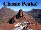
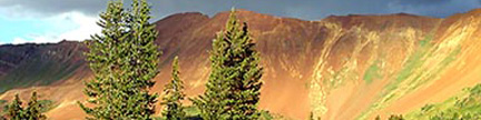
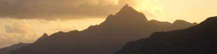
“Siberia Peak” – 13,420 feet
This dramatic Elk Range Thirteener perches between the Fourteeners Snowmass and Capitol in the northern Elk’s heartland. |
 |
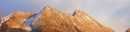
“Siberia Peak” seen from Lead King Basin
The main summit is on the right,
and the climbing route is up the sunlit east face above Siberia Lake
Gerry took this photo in May 1971 |
– Report by Jennifer Roach – Trip August 17, 1997
|
| Over a fifteen-year span, I had made multiple trips into Lead
King Basin to climb Snowmass Mountain, Hagerman Peak, and marvel at the blue
inkwell of Geneva Lake. Gerry had also visited this area several times. Yet
neither of us had ever ventured two miles north of Geneva Lake to the head of
the unnamed creek, which flows into Geneva Lake. I knew a nameless Thirteener
was waiting up there to be climbed by us, so we set about making this our sojourn
one lovely weekend in August of 1997. A hasty overnight car camp off FS Road
314 near Lizard Lake gave us an early start on our “Siberian Sortie.” |
 |
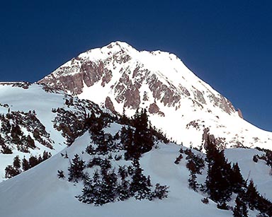
“Siberia Peak” from upper Lead King Basin |
| Getting up into Lead King Basin was a project, as we were well aware it might be. The jeep road
is notorious for being muddy and rough, and it can be impassable after a rainstorm.
Although there had been some recent rain, the road was dry enough to make our
four-wheel journey only moderately exciting. We followed the signs from Marble
directing us to Lead King Basin. We had a choice of two routes up into the basin,
and we knew that either would be challenging for my little gray Toyota pickup.
We chose to take the first split in the road, using FS Road 315 that climbs
high above the dashing waters of the North Fork of the Crystal River, then contours
into Lead King Basin. The rough sections were slow, and we bumped along in low
gear. My Toyota’s high clearance was especially appreciated as we trundled
over the roughest sections of the narrow road. Eventually, we got around the
slick hairpin bends, and proceeded five miles to the popular Geneva Lake North
Fork Trailhead. It was a relief to park, and get away from the steady grinding of the Toyota. |
| The trail up to Geneva Lake is heavily used, which we found perplexing since
the jeep road to the trailhead can be such a deterrent. The beauty of the
greenery and the waterfalls of the North Fork of Crystal Creek are enticing
and spectacular. Rainfall had been abundant that summer, so foliage was lush
and verdant. The creek was racing with good, clear water. After hiking a pleasurable
series of switchbacks on developed trail, we reached the shores of Geneva
Lake in two miles. Lots of folks love to camp here, making it a launching
point for trips up Snowmass Mountain or Trailrider Pass. These are great destinations,
but it was exciting to be headed to a new place. Although it was not shown
on our 7.5’ map, we found a spur trail heading north from Geneva Lake.
The trail traces along the North Fork, passing under the hidden Little Gem
Lake to the west. We hiked up several emerald green benches, and covered another
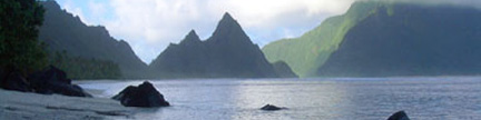
effortless two miles before reaching the trails terminus at Siberia Lake.
This beautifully situated lake sits in its own little bowl, rimmed by steep
walls on three sides. High above the lake’s west side, we finally gazed
at our goal, which is aptly named “Siberia Peak.” |
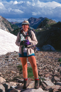 |
Jennifer in upper Lead King Basin |
| A rest stop at the Lake gave us time to pick out the route up the mountain.
The peak looks rough from the lake, but we spied a straightforward line. We
would take the ridgeline leading directly from the west shore of the little
lake and follow it northwest to 13,200 feet. From here, we would turn due
north and scamper to the top. The climb was a strenuous 2,500 feet from Siberia
Lake and all of it on blocky, sometimes unpredictably loose rock. This type
of terrain is the trademark of the Elk Range, and both Gerry and I knew from
our past experiences in this range to approach this rock scrambling with care
and caution. Slowly and thoughtfully, we picked our way up the ridge. Soaring
and steep, the ridgeline was a wonderful climbing experience. Each loose bench
took us yet farther up into the incredible heights of the Elk Mountains. On
this ridge, we were seated advantageously between Capitol Peak to the north
and Snowmass Mountain to the southeast. A sea of thirteen and twelve thousand-
foot peaks surrounded us. The occasional loose block of gray granite shifting
underfoot reminded us to stay focused on our safety. As predicted, we flattened
out at 13,200 feet, and scrambled over the tumbled blocks of the summit ridge
to “Siberia Peak’s” highpoint. |
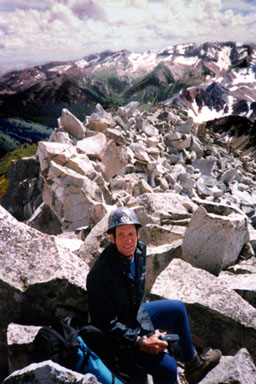 |
Gerry on top of “Siberia Peak” |
| It was a thrill for every one of our senses. Forgetting a camera or extra film on this day would have been unforgivable,
since the views were outstanding. Capitol Peak stood like some huge monolith to the north. A small aircraft
flew by its face, seemingly dwarfed in appearance. |
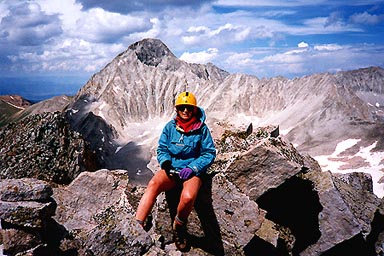 |
Jennifer on top of “Siberia Peak” with Capitol Peak behind |
| Turning our gaze 180 degrees, the mighty Snowmass Mountain loomed above the valley
from which we had just ascended. The rough southwest face of this Fourteener
is a jumble of granite blocks and slabs. Gazing due south, the massif of Treasury
and Treasure Mountains still held summer snows while the Raggeds poked up
behind them with majesty. Lakes sparkled everywhere. The day was beautiful
and rich, making us wish it could be summer for another six months. We took
some time to read through the summit register, placed there in 1968. The peak
was then nicknamed “Four C Peak,” but we had already elected to
call it “Siberia Peak.” |
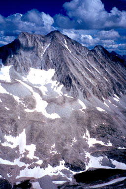 |
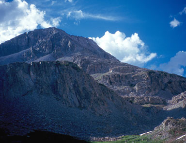
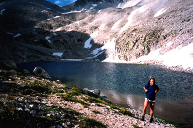
Snowmass Mountain from “Siberia Peak”
Sibera Lake is in the lower right |
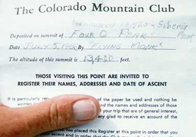 |
The “Siberia Peak” Register |
| Our descent was as well planned as our ascent. Especially around the summit
area, precariously moving blocks of rock surrounded us, so our movements were
gentle on this part of the climb. Finally, the ridge’s steepness relented
somewhat and we were able to move along at a faster pace. Gerry climbed down
with precision from years of dealing with loose rock, while I minced some
distance behind him. We chattered happily, roaring over a joke he relayed
from his recent expedition up Gasherbrum II in Pakistan. At last we touched
the shoreline of Siberia Lake once again, and breathed a little sigh of relief
to be off the tilting rock. Our break at the lake was well deserved, and it
was a pristine spot for reflection. Six months later, in the dead of winter,
I would think again about our break at this lake and the incredible beauty we drank in there. |
 |
Gerry tearing himself away from Siberia Lake |
| We had to tear ourselves away from this sacred spot. The trail down through the upper reaches
of the valley back to Geneva Lake seemed a cakewalk after the rough nature of
our peak, which we could still view behind us as we descended. The greenness
of the valley was so striking that it appeared pastoral to our eyes. We snapped
ever more photos. It was a rich and powerful day, one that we would recollect
fondly for years to come. Since that wonderful August day nearly six years ago,
I have remembered this particular climb as one of my favorite trips. It was
the pristine nature of the mountain and its environs, as well as the inspirational
effect that I felt which will draw me to the rocky slopes of “Siberia
Peak” again someday. |
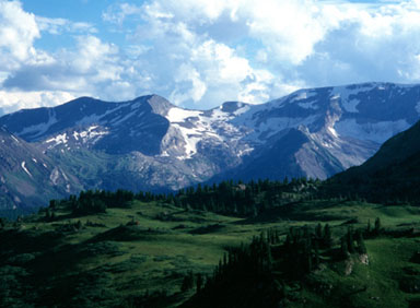 |
Afternoon delight in Lead King Basin |
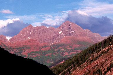 |
Late light on the Maroon Bells |
USGS 7.5’ Quadrangles: Snowmass Mtn., Capitol Peak
East Face –
From Geneva Lake: 4.8 miles RT, 2,460 feet net & total, Class 2+
From 4WD Park: 8.8 miles RT, 3,800 feet net & total, Class 2+
From Crystal TH: 12.8 miles RT, 4,420 feet net & total, Class 2+
|
| This is the easiest route on “Siberia Peak,” and it provides a classic Elk
Range ramble. The easy approach takes you through one of the Elk’s
most elegant arenas, but the summit climb is on the loose rock that
is typical of this area. Independent of the rock quality,
the summit views are stunning. |
| Start at the Crystal Trailhead at 9,000 feet or the 4WD parking place below
Lead King Basin at 9,700 feet, then follow the Lead King Basin Approach
to Geneva Lake at 10,960 feet. Information on the Crystal Trailhead and the
Lead King Basin Approach are on pages 194 and 195 of Gerry’s guidebook,
Colorado’s Fourteeners,
and also on pages 172 and 173 of our guidebook,
Colorado’s Thirteeners. |
| From Geneva Lake’s south end, continue 0.3 mile north on the trail around
Geneva Lake’s west side, and go a little beyond the lake to a trail
junction with the Trail Rider Pass Trail.
Do not turn right toward Trail Rider Pass, but continue 0.9 mile straight north on the now smaller trail,
climbing a bench en route, to Little Gem Lake at 11,660 feet.
Welcome to paradise. Continue 0.6 mile north on the fading but still adequate
trail to Siberia Lake at 11,860 feet, which is nestled between the Fourteener
Snowmass Mountain to the east and “Siberia Peak” to the west.
Your Class 1 trail approach ends here in this well composed place. Now for the summit climb. |
| Leave the comfort of the grass and flowers around Siberia lake,
climb 0.5 mile west-northwest up blocky rocks and reach “Siberia Peak’s”
north-south summit ridge south of the summit (Class 2). Turn north (right),
and carefully scamper 200 yards north to the summit (Class 2+).
The blocks on the summit ridge are quite large,
and some seem precariously balanced.
Remember that this is the Elk Range, which is known for rotten rock,
take your time and exercise extra caution here.
The sumptuous summit views will wait for you. |
Variation
|
| This alternative is 1.2 miles longer round trip, has 320 feet more
elevation gain round trip, keeps you on the rocks longer,
but avoids the balanced blocks south of the summit.
Instead of climbing diretly above Siberia Lake, continue 0.4 mile north
around Siberia Lake’s west side, and reach 12,100 feet in the basin north
of Siberia Lake. From here, choose your route, and climb 0.4 mile northwest
to reach “Siberia Peak’s” north ridge at 13,000 feet.
Turn south (left), climb 0.2 mile south to “Siberia Peak’s”
13,380-foot northern summit and continue 200 yards south to the
main summit. Ascending the direct East Face Route and descending this
variation makes a view-filled Tour de Siberia. |