You must get involved to have an impact.
No one is impressed by the won-lost record of the referee.
– John H. Holcomb |
Park Pointing
|
What is Park Pointing? |
| Park Pointing is the quest to reach the highest point of a National Park. There are currently 58 national parks in the United States.
The National Park Service administers far more than 58 “units,” but we are not concerned with national monuments, seashores,
battlefields or historic buildings only red-blooded national parks.
For a list of these 58 parks and highpoints, see our National Park Highpoint List.
Ken Akerman and Andy Martin originally compiled this list, I did my own research, added three new parks, and posted it for all to enjoy. |
Why Park Pointing? |
| A human creates state and county boundaries for some political reason, and these boundaries have little or nothing to do with
surrounding high ground. States are large enough that they usually include an interesting peak,
but counties are often left without a lusty highpoint. In contrast, we create a national park to covet an area of exceptional
natural beauty or significance. Most of our national parks are in the west, and most have momentous mountains for highpoints.
Consider Longs Peak, the Grand Teton, Mount Whitney, Mount Rainier and Mount McKinley to name a few.
Happily, five national park highpoints are also state highpoints, so a state completer has a head start on this park list.
Even if a park has nothing to do with high ground, it is still an area of great interest that is well worth a visit.
What better goal for a visit, than to seek the highpoint? |
| One of the charms of this activity is that it covers a wide range of outings.
Several of the park highpoints are wheelchair accessible, many are modest outings, and we all know those momentous mountains.
Recent trips to the highpoints of Great Sand Dunes and Capitol Reef National Park, both of which are ‘liners,’
convinced me that even a liner can provide a great outing leading to stunning views that few visitors to those parks ever see.
Nine park highpoints are on islands, and we have national parks in the Virgin Islands and American Samoa.
Park Pointing provides something for everybody. |
Our Book |
| Dave Covill, John Mitchler and myself are working on a guide to the 58 national park highpoints.
Even with three of us working on the project, it has a huge scope. We welcome trip reports from your recent adventures,
especially to the more obscure parks. Be as specific as possible. If you contact us in advance of your park highpoint trip,
we will provide you with a proof of that description, so you can check it out. |
Recent Activities |
| In 2004, I led a group to Alaska’s Valley of Ten Thousand Smokes,
where we climbed Mount Griggs
the highpoint of Katmai National Park. Alaska, with eight national parks, looms large in the park highpointing quest. |
| I started 2004 with visits to highpoints in Joshua Tree, Rocky Mountain,
Big Bend, Guadalupe, Carlsbad Caverns, Saguaro, Petrified Forest, Channel Islands, Grand Canyon, Zion, Great Basin, Olympic,
Katmai, and Black Canyon National Parks. Then, on a whirlwind 3-day weekend with Dave Covill, I finished the year with visits to
Wind Cave, Badlands, and all three units of Theodore Roosevelt National Parks. Dave Covill and John Mitchler compiled
equally impressive lists, and together we have now visited the highpoints of 48 of the 58 national parks.
Dave was successful in reaching the highpoint of Dry Tortugas a more challenging highpoint then you might imagine.
Only 10 feet above sea level, it requires a water crossing, and one quickly learns about tides, winds, swells, chop,
encamped Cuban immigrants, and oh yes, hurricane season. Used to discussing the differences between snow and ice crampons,
I am now enjoying learning about ancient native-made shell middens, and of course I immediately asked if they ‘count’
if they are old enough. Six people ran screaming from the room when I brought this up, but another dozen ran screaming into the room,
so I guess it was a good question. |
| Adam Helman has created a nice map showing the 58 US National Parks. It is located at
http://www.cohp.org/natl_parks/images/national_parks.gif.
People can post their “completion map” to the cohp site. |
| Your trusty authors were busy with a number of projects during the summer of 2005, and visited several notable park highpoints.
In May, John Mitchler and his new wife Kathy Dalsaso, with Gerry and Jennifer Roach, took the park-pointing idea abroad,
and completed all the national park highpoints in Scotland. There are only two, but they are good ones
the famous Ben Lomond rising above Loch Lomond and also Ben Macdui in the Cairn Gorms. In June, Gerry joined forces with
50-state completer Burt Falk and climbed Lata Mountain the highpoint of American Samoa and the National Park of American Samoa.
The 3,100-foot ascent took two days at “Machete Speed,” which is the same speed as summiting Everest
about 200 vertical feet per hour. Gerry scattered Jack on the highest point, which was on the edge of a steep escarpment
dropping dramatically to the ocean. In July, John and Dave Covill reached the highpoint of Kenai Fjords National Park,
which is a nunatack rising above the Harding Icefield near Seward. This unique ascent is certainly a first for the Highpointers Club,
and may be only the second ascent of the nunatack. John and Gerry also managed ascents of North Palisade in the Sierra
the highpoint of Kings Canyon National Park. |
| In May of 2006 I took an eastern state highpoint tour
where I also touched the highpoints of seven eastern national parks, then the summer yielded another surprise.
In July, John Mitchler reached the highpoint of Alaska’s Kobuk Valley National Park the elusive 4,670-foot
Mount Angayukaqsraq, which is the northernmost national park highpoint in the US. This is likely a first ascent,
and certainly a first for the Highpointers Club. When John, Dave and I started our park book and quest, I assumed that there
would be some unknowns left at publication time. However, at this point we have been to, or have solid information on,
the highpoints of all 58 US national parks. Our age of exploration is far from over, but the complete mysteries have been trundled. |
Featured Parks |
| Each quarter, I will feature one park highpoint, and give basic information to get you there.
When you turn a guidebook author loose on a column, this is bound to happen! |
|
| For Fall 2004, it’s 5,013-foot Rankin Ridge the highpoint of Wind Cave National Park.
This short, one-mile hike makes a perfect addition to your visit to South Dakota’s Black Hills.
Wind Cave is close to Black Elk Peak South Dakota’s state highpoint, as well as Mount Rushmore and the Needles.
Either coming or going from your visit to Wind Cave itself, take time to hike up Rankin Ridge.
The following basic directions should help you. From the Wind Cave National Park Visitor Center area,
go northwest on U.S. 385, turn north onto South Dakota 67, go 4.8 miles north passing a circular turn
where the road passes over itself en route, and turn east onto the Rankin Ridge Road.
Go 0.3 mile east to the well-marked trailhead at 4,750 feet. Hike up the gourmet Rankin Ridge Nature Trail,
and reach the lookout tower on top after a mighty half-mile hike. From the top, you can see the forested hills
and open meadows typical of the Black Hills, and if you are lucky you might see a herd of buffalo.
Complete your loop hike by descending the access road back to the trailhead. |
|
| For Spring, 2005, it’s 1,410-foot Music Mountain, which is the highpoint of Hot Springs National Park in Arkansas.
If you look at the distribution of national parks in the US, you immediately see a lack of parks in the center of the country.
However, one of the oldest parks in the system is in central-west Arkansas. It is Hot Springs National Park,
which is located southwest of Little Rock and north of Magazine Mountainthe highpoint of Arkansas.
Congress established Hot Springs Reservation on April 20, 1832 to protect hot springs flowing from the western slope of Hot Springs Mountain.
This makes it the oldest area currently in the National Park System40 years older than Yellowstone National Park.
People have used the hot spring water in therapeutic baths for more than two hundred years to treat rheumatism and other ailments.
The reservation eventually developed into a well-known resort nicknamed “The American Spa”
because it attracted not only the wealthy but also indigent health seekers from around the world.
Today the park protects eight historic bathhouses with the former luxurious Fordyce Bathhouse housing the park visitor center.
The entire “Bathhouse Row” area is a National Historic Landmark District that contains the
grandest collection of bathhouses of its kind in North America. By protecting the 47 hot springs and their watershed,
the National Park Service continues to provide visitors with historic leisure activities such as hiking, picnicking, and scenic drives.
Hot Springs Reservation became Hot Springs National Park by a Congressional name change on March 4, 1921. |
| The highpoint of Hot Springs National Park is 1,410-foot Music Mountain, which is near the western border of this small park.
The short hike to this highpoint gives you a chance to stretch your legs on a long, cross-country drive.
From the intersection of US 70 and AR 7 (Central Avenue) in the center of Hot Springs, go north on AR 7,
turn southwest (left) onto Whittington Avenue and go a mile to a loop road. From the west end of the loop road,
continue west on Black Snake Road (dirt) for another 1.2 miles to a saddle at 630 feet.
The Sunset Trail crosses the road here, and this is the trailhead. Parking here is limited.
Hike 0.8 mile southwest up the Sunset Trail, which generally follows a ridge.
When the trail crests and starts to descend, leave it and bushwhack 120 feet east to the highpoint.
Caution: while the final bushwhack to the highpoint is short, it is through waist-high grass,
which harbor chiggers in the summer. In winter, you won’t have this problem. |
|
| When you look at the distribution of U.S. national parks, two states hold more than a quarter of all the parks.
Alaska and California have 8 national parks each, and these 16 parks cover much of the spectrum covered by all
58 U.S. national parks. There are hot desert hikes, Sierrascapes, Cascade volcanoes, huge glaciated peaks, and Arctic surprises.
None of these park highpoints are even close to being a drive-up. It’s time to move west, grab your boots, and get moving!
This issue, I’ll focus on one of those hot hikes across the Mojave Desert. The park is Joshua Tree in southern California,
and it’s highpoint is 5,820-foot Quail Mountain. |
| Unlike the mountain parks, Joshua Tree National Park can seem unwelcoming during the summer heat when the land often appears
defeated and dead. Two deserts come together in the park, and few areas more vividly illustrate the contrast between “high”
and “low” desert. Below 3000 feet, the Colorado Desert, which occupies the eastern half of the park,
is dominated by the abundant creosote bush and dotted with small stands of spidery ocotillo and cholla cactus.
The higher, cooler, and wetter Mojave Desert is the habitat of the undisciplined Joshua Tree,
and extensive stands occur throughout the western half of the park. According to legend, Mormon pioneers considered the limbs of
the Joshua trees to resemble the up-stretched arms of Joshua leading them to the promised land. Others were not as visionary.
Early explorer John Fremont described them as, “
the most repulsive tree in the vegetable Kingdom.”
Whatever their genesis, they stand like oases in a desolate desert sea, and they have their very own national park. |
| Above the Joshua trees rise rugged mountains of twisted rock and exposed granite monoliths that attract rock climbers
from all over the world. The park has more than 3,000 rock climbing routes. Not to be outdone, hikers heading for the heights
can enjoy arroyos, playas, alluvial fans, bajadas, pediments, desert varnish, granites, aplite, and gneiss,
all of which interact to paint a cherished montage. At the edges of clear night skies, the desert animals who have waited out
the daytime heat, run, hop, crawl, and burrow in the slow rhythm of their desert life. Under bright sun and blue sky,
bighorn sheep and golden eagles add an air of unconcerned majesty to the moving mosaic. |
| There are two hikes that will take you to the top of Quail Mountain. I will describe the longer hike that starts from the park road.
Start by driving to the Quail Springs Picnic Area. Measure from the junction of CA 62 and Park Blvd on the west side of Twentynine Palms.
Go south on Park Boulevard, which soon becomes the Quail Springs Road, and enter Joshua Tree National Park at mile 5.2.
Pass a large pullout on the east side of the road at mile 9.3, and turn west (right) into the Quail Springs Picnic Area at mile 11.1.
Go 200 yards to the northwest parking lot, which is on the west side of some famous formations that attract rock climbers.
You cannot see Quail Mountain from the trailhead. |
| The beginning of the trail is not marked or obvious. To find it, go to the northwest corner of the parking lot,
then go south for 50 feet along the edge of the parking lot until you see a vague lane heading west-northwest across the desert.
This is the old road that shows on the maps. Hike this road, going slightly downhill, and after 1.0 mile, reach the base of the hills
west of the highway. Continue on the old road for another 0.9 mile as it turns west and reaches the open area at the bottom of
Johnny Lang Canyon. Angle 0.5 mile southwest and pick up an old trail on the west side of Johnny Lang Canyon.
Stay on the west side of the canyon, and hike 1.2 miles southeast up Johnny Lang Canyon to 4,100 feet where you can clearly see
the old Lang Mine ahead of you. It is not necessary to follow the trail to the mine, which is perched on a steep hillside. |
| Leave the trail at 4,100 feet before it climbs the steep hill to the mine, and hike 0.5 mile west up a gentle gulch to reach a
ridge crest at 4,660 feet. From here you can finally see Quail Mountain. Hike 0.6 mile south up the rounded ridge to Point 5,405,
from which you can see the rest of the route. Descend 0.5 mile southwest to a diffuse 5,180-foot saddle, climb sprightly 0.5 mile
west to the north end of Quail’s summit ridge, and walk 200 yards south to the large cairn that marks the highpoint.
There is a 5,813-foot benchmark and a register on the north end of the ridge, and the maps indicate this as the summit of the mountain,
but we estimate that the elevation of the highpoint on the south end of the summit ridge is 5,820 feet. To avoid extremes,
this hike is best done in the spring or fall. |
|
| Oregon only has one national park, but it’s a good one. Crater Lake sits astride the Cascade Crest in southwest Oregon.
Framed by steep cliffs capped by evergreens, circular Crater Lake is the namesake for Crater Lake National Park.
Actually the caldera of an old volcano, Crater Lake is the deepest lake in the United States. Thousands of years ago,
mighty Mount Mazama erupted, then collapsed, leaving Crater Lake to slowly fill with water. The lake is widely known for its
intense blue color. Now stable, the lake level has only varied 16 feet in modern history. |
| The park highpoint is Mount Scott, which is not on the rim directly above Crater Lake, but is a separate, much smaller
crater remnant a few miles east of the lake’s eastern rim. Scott’s summit rises over a thousand feet above the crater rim,
almost two thousand feet above Crater Lake, and almost four thousand feet above the bottom of the lake. High for the Cascades,
Mount Scott captures a lot of snow in winter, but by August the peak is dry and the fire lookout on top is often in use.
In August, the ascent is an easy trail hike, but serious snow still shrouds the peak in June. The park road around the lake’s
east side often does not open until July. Plan your trip accordingly. |
| If approaching from the south or west, measure from the junction adjacent to the main visitor center, and go 12.1 miles north
on Rim Drive around the east side of Crater Lake. The well-signed trailhead is on the east (right) side of the road just beyond
the turn for the Cloudcap Overlook. If approaching from the north, measure from the junction of the north entrance road and Rim Drive,
and go 11.1 miles south on Rim Drive around the east side of Crater Lake to reach the trailhead. |
| From the south end of the parking lot at the Mount Scott Trailhead, hike east past the trail signs, and follow the trail
south along a broad ridge. This ridge is the western rim of Mount Scott’s old, eroded crater, and it provides an unobstructed
view of Mount Scott. From the ridge, continue south into the trees and begin a steady ascent. After the trail slowly turns to the east,
you will have an open view to the south, and sharp eyes can just pick out the upper snows of Mount Shasta, far to the south in California.
The ridge above climbs faster than the trail, and the trail finally switchbacks, steepens, and climbs to the crest of Scott’s
southwest ridge. This is a fine viewpoint, and it is worth taking a few extra steps to peer into the basin that speaks of Scott’s
volcanic origin, and beyond to Crater Lake. The trail switchbacks at the ridge, then switchbacks twice more to reach the ridge a
second time at a higher vantage. The trail switchbacks a fifth time at a viewpoint where you have your first open view to the east.
Shortly above this point, the trail cuts through the rocks to reach the summit ridge, where you can easily see the fire lookout,
which is now only a few hundred yards ahead. The broad, nearly level summit ridge provides a sanguine passage to the fire lookout.
The highest natural point is a boulder just south of the lookout, and the boulder has two benchmarks on it.
This 5.0 mile round-trip hike has 1,329 feet of gain. |
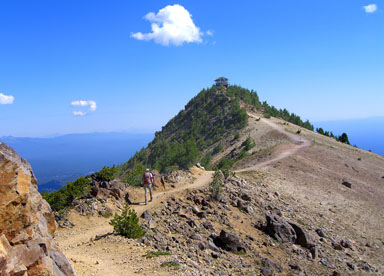 |
Striding along Mount Scott’s summit ridge on a perfect August day |
|
|
| The December issue of Backpacker Magazine is dedicated to the National Parks and I have extracted some interesting factoids. |
| Denali is growing! Several hundred million years ago, seas covered much of central Alaska, and as the water receded,
marine sediments hardened to form the 600-mile long Alaska Range. Later, tectonic forces pushed these sedimentary peaks skyward.
Denali joined the Alaska Range a mere 56 million years ago. After a blob of molten magma solidified below the surface,
new tectonic forces pushed it up while the surrounding softer rock eroded away. Because of these different erosion rates,
Denali’s local uplift continues today, and it is growing faster than the surrounding peaks.
Denali is growing about a foot every 300 years, so it will be awhile before you need supplemental oxygen. |
| Wind Cave National Park is negotiating with both Congress and surrounding land owners, seeking to increase the size of the park by 20%. |
| The National Park of American Samoa is also seeking to expand the park unit on tiny Ofu Island.
Lata Mountain, located on neighboring Tau Island, would remain the park highpoint, but the highpoint of the Ofu unit would change. |
| There are movements for several new national parks, notably at Mt Hood, Glen Canyon, and the desert west of Organ Pipe National Monument.
With the golden age of park creation behind us and a park budget that is running in the red, it seems unlikely that these will all become parks.
However, we welcome any new park for the protection it offers, and of course, the new highpoint! |
|
| Well, it was bound to happen. The National Park Highpoint project lured me away from the snowy summits, and I found myself in Florida
seeking the three park highpoints there. I was also lured by the fact that John Mitchler and his wife Kathy Dalsaso had planned a trip
and chartered boats to ease the access problems to the outer keys. Understanding their organizational capabilities, I decided to
“clip in” to their trip. |
| First up was Dry Tortugas where I quickly learned about hurricane season, tides, wave height, and currents. I also remembered what it feels
like to be out of sight of land in a small boat, since this height-seeking land-lubber had not done that for over 30 years. Our charter boat
from Key West took a day and a half to traverse the 70 miles to the park, but a bonus was that we got to spend a night on a deserted beach
in the Marquesas Keys. The next day we grounded the boat leaving our little paradise and learned some more about tides. After blasting across
the wave tops at 30 knots, we reached the park, eschewed Garden Key, which is served by the Ferry, and went straight for Loggerhead Key.
With the highpoint in sight, a park ranger appeared and told us that we couldn’t land because there were illegal Cubans on the island.
We pleaded our case and he relented. After a few strides to the highpoint, I proclaimed it to be the most unique 10 feet that I had ever
“climbed.” |
| Two days later we blasted across Biscayne Bay in another specialized boat, tiptoed across mangrove roots rising out of the water to reach coral,
then bushwhacked onto both Totten and Old Rhodes Keys to claim the twin 9-foot highpoints of Biscayne National Park. This is the lowest of the
58 US national park highpoints, and quite a difficult one to reach! Biscayne protects the last remaining natural shoreline in southeast Florida
and the sea creatures that live in the shallow waters between the outer keys and the coast, notably the gentle Mantee. We observed a lot of
hurricane damage, beached boats and clambered over many felled trees on the outer keys. I remember a story about two guys who decided to ride out
a hurricane on Totten Key. They found one body fairly quickly, but the other one didn’t show up for several months. They messed up their math.
A big hurricane can produce 30-foot surges, and Totten Key is only 9 feet high. Another lesson. |
| After saying thanks and goodbye to John and Kathy, I hustled to the highpoint of Everglades National Park. What a relief to just drive somewhere
and go for a walk! Thus, I reached the highpoints of all three of Florida’s national parks in 4 days, which is probably a speed record.
Of course, these park adventures will be written up in detail in our Park Highpoint book! |
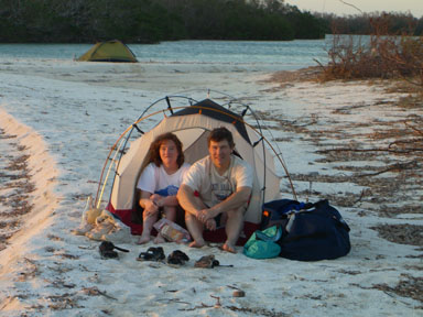 |
Kathy Dalsaso and John Mitchler in the Marquesas en route to the highpoint of Dry Tortugas National Park |
|
| Now, to compensate for Florida’s flatness, I will discuss another tough park highpoint 14,242-foot North Palisade, which is the highpoint
of Kings Canyon National Park. The fourth highest peak in California and one of California’s fabled Fourteeners, North Palisade is considered
by many to be the toughest of them all. Striking from all vantages, it is certainly a classic Sierra peak. The Palisade Glacier at the base of the
peak’s north face is the largest glacier in the Sierra. Steep on all sides, North Palisade offers many routes for climbers of all abilities,
but even the easiest route is a technical climb. |
| The adventure, normally done with a backpack, starts at the South Lake Trailhead and requires 19 miles, almost 6,000 feet of climb, and a Class 5.3 crux.
To reach the trailhead, start at the southernmost stoplight in Bishop on US 395, turn west onto West Line Street, go west, turn left toward South Lake
en route, and reach the trailhead at the end of the road at mile 18.5. The trailhead is near the dam at the north end of South Lake, just beyond
the boat ramp. |
| Your backpacking approach is a semi-circular hike around the west end of the Palisade Crest that consists of a trail hike to Bishop Pass,
a traverse of beautiful Dusy Basin, a crossing of rocky Thunderbolt Pass, and a descent into Palisade Basin. Thunderbolt Pass is not named on the
USGS North Palisade Quadrangle or other maps derived from this source. Rangers on the trail are likely to ask to see your permit, so stow it
in an easily accessible place. Do not confuse Palisade Basin on the south side of North Palisade with the Palisade Glacier on the north side
of the peak. |
| The summit climb from Palisade Basin is complicated, and I will just summarize it here. Contour and climb east across Palisade Basin to 12,300 feet.
The LeConte Route starts up the broad, talus-filled gully to the southeast (right) of the Southwest Buttress. This is the middle and widest of the
three gullies between four white buttresses, and it is called the Southwest Chute. This major chute goes all the way up to the U Notch, which is
between North Palisade and 14,100-foot Polemonium Peak. Ascend the Southwest Chute to 13,200 feet, and look sharp to the west (left) side of the chute.
The key is a narrow, hard-to-see ledge that crosses the otherwise near-vertical cliff, and grants you passage out of the Southwest Chute into
the next gully to the west. There is a black water streak on the cliff above the middle of the ledge that may be frozen early in the morning.
Find, climb onto, and descend this exposed escape ledge. Go around a corner, scamper west to the base of the next gully, and scramble up this gully
to 13,600 feet. Climb a 100-foot, Class 4 pitch on clean rock, then scamper up to the first of two famous chockstones, which are the route’s crux.
To further complicate your ascent, there is often snow below both chockstones. Bypass the first chockstone on its left side (Class 4),
and bypass the second chockstone system on its right side (Class 5.3). |
| Above the second chockstone, scamper 100 feet up and slightly right to a small, 13,800-foot saddle. Cross the saddle and enter a large gully
to the right of the chockstone gully. Ascend this gully on loose rock and dirt, climb past yet another chockstone on its right side (easy Class 3),
and continue up until the gully widens into the summit bowl. From here, you can see North Palisade’s summit rocks above you to the left.
Climb toward the summit ridge running east of the summit, but do not go all the way to the ridge. One hundred feet below the ridge,
find a ledge system with a white streak of rock in it, and follow this ledge up to the left for 100 yards. When a steep, 15-foot-high,
east-facing wall blocks easy progress, leave the ledge and climb up to the right. Climb straight up for 20 feet then continue angling right
toward the summit ridge up a steep, V-shaped weakness. From an unlikely stance, zig 10 feet downhill to the left to the top of an overhanging boulder.
Wiggle 5 feet up a one-foot-wide crack to avoid a more exposed route. Go west toward the top through a roomy opening between huge rocks.
Climb five feet up to a nice one-foot-square platform, then take a big step up onto a banister-like boulder. The last 20 feet to the
summit boulder are easy! |
| You are on the highest point in Fresno County, and can look down to the Palisade Glacier on the peak’s north side and marvel at its size.
Lifting your eyes, you can scan much of the Sierra, and if the air is clear, you can squint south and just see Mount Whitney.
If you are planning a trip to this imposing peak, contact us, and we will give you our complete write up to try out! |
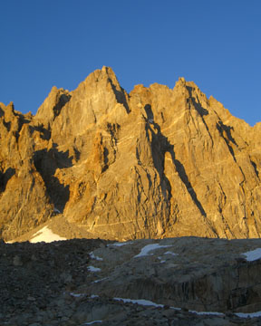 |
North Palisade from Palisade Basin
North Palisade is the highpoint of Kings Canyon National Park |
|
|
| For this feature park, I’d like to discuss a highpoint far from Alaska that any hiker can do. It’s 7,825-foot
Emory Peak in Texas’ Big Bend National Park. Most highpointers are familiar with 8,749-foot Guadalupe Peak,
the highpoint of the other national park in Texas, since it’s the state highpoint. Emory Peak offers a similar hike
in the center of the Chisos Mountains. Emory Peak holds two other distinctions besides being a park highpoint -
it is also the highpoint of Brewster County and is the southernmost park highpoint in the western 48 states. |
| Big Bend includes mountain, desert, and river environments, and the terrain falls steeply away from Emory Peak
to the Rio Grande River, which is only an hour’s drive away at the humble altitude of 1,800 feet.
Between the peak and the river lies the largest protected area of Chihuahuan Desert in the US.
South of the river lie the Mexican states of Chihuahua and Coahuila, and people there call the Rio Grande by its
Spanish name, Rio Bravo del Norte. Emory Peak is best hiked in the spring or fall, but beware of hot temperatures
if you descend to the river. |
| The journey up and down Emory Peak is a modest day hike, but your biggest concern is likely to be arranging
the travel to the trailhead, since Big Bend is a long way from most US cities. That’s part of the charm of this hike.
Go to the small town of Marathon, Texas 22 miles east of Alpine on US 90. From Marathon, go 43 miles south on US 385
to the Persimmon Gap Visitor Center at the north entrance to Big Bend National Park. From here, go another 26 miles
south to the main Panther Junction Visitor Center, which is just west of Panther Junction. Go 3 miles west on TX 118,
turn south (left) onto the Chisos Basin Road, and go 6 miles south over Panther Pass into the Basin. There is a
campground here, which is usually full in the spring, since this is a popular destination during spring break
for many area schools. The well-signed trailhead for your hike is just south of the Chisos Mountain Lodge area.
The trailhead is at 5,400 feet, which leaves you with a net gain of 2,425 feet to the top of Emory Peak. |
| From the trailhead, simply follow the Emory Peak Trail, which is well-signed. It is 4.5 miles one-way to the summit.
The trail climbs steadily, then switchbacks up a steep escarpment to reach the highlands at 7,000 feet.
Descend gently southeast for 200 yards, then turn southwest (right) onto the summit trail. As you approach the peak,
you may be surprised to see that it is a rock summit, not just a hump. When the trail finally bumps into the summit rocks
you have a choice. For the easiest route, walk north (right) along the base of the rocks, go around a small corner,
then look up to see a small northeast-facing chute. Scamper up in or just to the left of the chute for 30 feet to reach
easier ground above (Class 2+). Your other choice is to climb the 20-foot wall right above the point where the trail
bumps into the summit rocks (Class 3). If you move to your left during this climb, you may be surprised by some
significant exposure. Either way, once above the initial wall, scamper on up to the summit (Some Class 2+).
Ignoring the solar-powered radio tower on top, you have an expansive view in all directions. |
| For a little Extra Credit, scamper back down the summit rocks, move south across a little notch, and scamper west
up to a small southern summit. From this airy perch, you get a dramatic view of the main summit, and you may be
surprised at how cliffed it really is. For more Extra Credit, you can combine the hike to Emory Peak with a hike
to the South Rim where you can gaze down across the low desert peaks to the Rio Grande. In particular, you can ponder
Elephant Tusk.
|
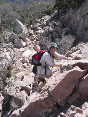 |
Jennifer Roach climbing the Class 3 wall above the Emory Peak Trail |
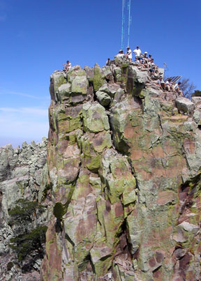 |
The summit of Emory Peak on a busy spring day |
|
High or low, happy hiking!
– Gerry Roach |